Generating a Google Map with multiple markers and info windows 8/2/13
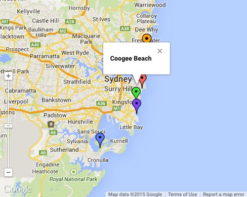
I recently needed to generate a Google Map with multiple markers and popup info windows. Easy, right? The twist was that I also wanted the marker pins to be different colors and I needed the map to auto center.
Here’s the script I pulled together to make it happen:
<!DOCTYPE html>
<html>
<head>
  <meta http-equiv="content-type" content="text/html; charset=UTF-8">
  <title>Google Maps Multiple Markers</title>
  <script src="http://maps.google.com/maps/api/js?sensor=false"></script>
</head>
<body>
  <div id="map" style="width: 500px; height: 400px;"></div>

  <script>
    // Define your locations: HTML content for the info window, latitude, longitude
    var locations = [
      ['<h4>Bondi Beach</h4>', -33.890542, 151.274856],
      ['<h4>Coogee Beach</h4>', -33.923036, 151.259052],
      ['<h4>Cronulla Beach</h4>', -34.028249, 151.157507],
      ['<h4>Manly Beach</h4>', -33.80010128657071, 151.28747820854187],
      ['<h4>Maroubra Beach</h4>', -33.950198, 151.259302]
    ];

    // Setup the different icons and shadows
    var iconURLPrefix = 'http://maps.google.com/mapfiles/ms/icons/';

    var icons = [
      iconURLPrefix + 'red-dot.png',
      iconURLPrefix + 'green-dot.png',
      iconURLPrefix + 'blue-dot.png',
      iconURLPrefix + 'orange-dot.png',
      iconURLPrefix + 'purple-dot.png',
      iconURLPrefix + 'pink-dot.png',
      iconURLPrefix + 'yellow-dot.png'
    ]
    var iconsLength = icons.length;

    var map = new google.maps.Map(document.getElementById('map'), {
      zoom: 10,
      center: new google.maps.LatLng(-37.92, 151.25),
      mapTypeId: google.maps.MapTypeId.ROADMAP,
      mapTypeControl: false,
      streetViewControl: false,
      panControl: false,
      zoomControlOptions: {
         position: google.maps.ControlPosition.LEFT_BOTTOM
      }
    });

    var infowindow = new google.maps.InfoWindow({
      maxWidth: 160
    });

    var markers = new Array();

    var iconCounter = 0;

    // Add the markers and infowindows to the map
    for (var i = 0; i < locations.length; i++) {
      var marker = new google.maps.Marker({
        position: new google.maps.LatLng(locations[i][1], locations[i][2]),
        map: map,
        icon: icons[iconCounter]
      });

      markers.push(marker);

      google.maps.event.addListener(marker, 'click', (function(marker, i) {
        return function() {
          infowindow.setContent(locations[i][0]);
          infowindow.open(map, marker);
        }
      })(marker, i));

      iconCounter++;
      // We only have a limited number of possible icon colors, so we may have to restart the counter
      if(iconCounter >= iconsLength) {
      	iconCounter = 0;
      }
    }

    function autoCenter() {
      //  Create a new viewpoint bound
      var bounds = new google.maps.LatLngBounds();
      //  Go through each...
      for (var i = 0; i < markers.length; i++) {
				bounds.extend(markers[i].position);
      }
      //  Fit these bounds to the map
      map.fitBounds(bounds);
    }
    autoCenter();
  </script>
</body>
</html>
Here’s a screenshot of what it should look like:

This script is a combination of code I found on Colin Wiseman’s website and Stack Overflow with a bit of my own to handle the different marker colors.
Update 2/17/2015: I removed the code that added separate shadow images behind the markers. As of version 3.14 of the Google Maps API, these shadows were being ignored. If you want shadows, you’ll need to use marker images with the shadows already in them. I also took this opportunity to clean up the code a bit, and remove the dependency on jQuery.
